


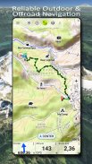
US Topo Maps
US Topo Maps açıklaması
ABD için mevcut en iyi haritalara ve hava görüntülerine ücretsiz erişim sağlayan, kullanımı kolay dış mekan navigasyon uygulaması.
Mükemmel yolculuğu planlamak için 30'dan fazla harita katmanı (topolar, antenler, deniz haritaları, ...) arasından seçim yapın ve
Kırsal bölgelere çevrimdışı geziler için Andoid Telefonunuzu/Tabletinizi bir dış mekan GPS'sine dönüştürün.
Diğer kaynaklardan kolayca harita ekleyin (GeoPDF, GeoTiff, WMS gibi Çevrimiçi Harita Hizmetleri, ...)
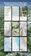
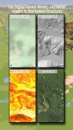
ABD için mevcut temel harita katmanları:
• USGS Ulusal Harita Topo
• USGS Ulusal Harita Görüntüsü Topo
• USGS Ulusal Harita Görüntüleri
• USGS NAIP HiRes Görüntüleri
• USGS Topo geleneksel DRG'leri: 1:250.000, 1:100.000, 1:63.000 ve 1:24.000/25.000 Ölçeklerinde ABD'nin topo haritalarının kesintisiz kapsamı
• FSKopo Orman Haritaları
• NOAA Denizcilik RNC Haritaları
• Ulusal Yükseklik Haritaları (Hillshade, Eğim Haritası, Bakı Haritası)
Dünya çapındaki temel harita katmanları:
• OpenStreetMaps (5 farklı harita düzeni), yerden tasarruf sağlayan vektör formatında da indirilebilir
• Google Haritalar (Uydu görüntüleri, Yol ve Arazi Haritası)
• Bing Haritaları (Uydu görüntüleri, Yol Haritası)
• Gece Dünya
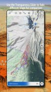
Bir temel harita katmanını bir kaplama olarak yapılandırın ve haritaları birbirleriyle sorunsuz bir şekilde karşılaştırmak için bir şeffaflık fader'ı kullanın.
Diğer kaynaklardan haritalar ekleyin:
• GeoPDF, GeoTiff, MBTiles veya Ozi'ye (Oziexplorer OZF2 ve OZF3) tarama haritalarını içe aktarın
• Web haritalama hizmetlerini WMS veya WMTS/Tileserver olarak ekleyin
• OpenStreetMaps'i Vektör formatında içe aktarın, örneğin yalnızca birkaç GB için tam ABD
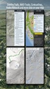
Mevcut ABD haritası Kaplamaları - diğer herhangi bir temel haritaya ek bilgi ekleyin:
• Kamu Arazi Mülkiyeti (PAD-US 3)
• Ulusal Hidrografik Veri Kümesi
• Motorlu Taşıt Kullanım Haritası (USDA)
• Yükseklik Kontur Çizgileri
• 4WD Parkurları
• Parkurlar
• Yollar, Demiryolları, Havaalanları
Dünya çapında mevcut kaplamalar:
• Tepe gölgeleme katmanı
• 20m Kontur Çizgileri
• OpenSeaMap
Mükemmel bir harita yoktur. En ilginç rotayı bulmak için farklı harita katmanları arasında geçiş yapın veya haritaları karşılaştırma özelliğini kullanın. Özellikle eski geleneksel DRG'ler, modern haritalarda eksik olan birçok küçük yol veya başka özellik içerir.
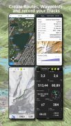
Dış mekan navigasyonunun ana özellikleri:
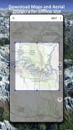
• ÇEVRİMDIŞI KULLANIM için harita verilerini indirin
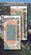
• Yolları ve alanları ölçün
• Yol Noktaları oluşturma ve düzenleme
• Yol Noktasına Git Navigasyonu
• Rotalar oluşturma ve düzenleme
• Rota Navigasyonu (Noktadan Noktaya Navigasyon)
• Takip Kaydı (hız, yükseklik ve doğruluk profiliyle)
• Kilometre sayacı, ortalama hız, yön, yükseklik vb. alanlara sahip Tripmaster.
• GPX/KML/KMZ İçe/Dışa Aktarma
• Arama (yer adları, İÇN'ler, sokaklar)
• Yüksekliği ve mesafeyi öğrenin
• Harita Görünümü ve Tripmaster'da özelleştirilebilir veri alanları (örn. Hız, Mesafe, Pusula, ...)
• Yol Noktalarını, Yolları veya Rotaları Paylaşın (e-posta, Dropbox, WhatsApp, .. yoluyla)
• WGS84, UTM veya MGRS/USNG (Askeri Şebeke/ ABD Ulusal Şebekesi) koordinatlarını kullanın,
• Parça Tekrarı
• ve daha fazlası ...
Bu navigasyon uygulamasını yürüyüş, bisiklet, kamp, tırmanma, binicilik, kayak, kano, avcılık, kar arabası turları, offroad 4WD turları veya arama kurtarma (SAR) gibi açık hava etkinlikleri için kullanın.
WGS84 verisi ile boylam/enlem, UTM veya MGRS/USNG formatında özel yol noktaları ekleyin.
GPS Yol Noktalarını/İzleri/Rotaları GPX veya Google Earth KML/KMZ formatında İçe Aktarın/Dışa Aktarın/Paylaşın.
Yağmurun ne zaman başlayacağı/duracağı konusunda doğru tahminler yapmak için animasyonlu NEXRAD yağmur radarına bakın
Lütfen sorularınızı, yorumlarınızı ve özellik isteklerinizi support@atlogis.com adresine gönderin.
US Topo Maps - Sürüm 7.8.0
(08-05-2025)US Topo Maps - APK Bilgisi
APK sürümü: 7.8.0Paket: com.atlogis.northamerica.freeUS Topo Maps uygulamasının en son sürümü
Diğer sürümler


 4.15
4.15


 4.33
4.33Aynı kategorideki uygulamalar

Hoşuna gidebilecekler...


